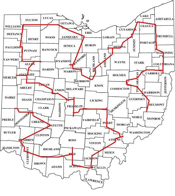
Since it’s Throwback Thursday (#TBT), I thought I’d share the story of 2 friends of mine and I who visited all 88 counties in Ohio in 24 hours (well, technically it was 23 hours, 34 minutes and 34 seconds). We all subscribe to the philosophy of the Extra Miler’s Club, whose motto is that “the shortest distance between two points is no fun”. Several of us (myself included!) have the goal of visiting all 3,143 counties in the United States
We did this on November 9-10, 2006.
The route
Solving “the fastest time to visit 88 places” is analogous to the Traveling Salesman Problem, which is actually considered not yet solvable in mathematical circles. Now, I know what you’re probably saying – “But Dan, visiting every county in a state is analogous to finding a shortest tour in a graph which visits all specified disjoint subsets of the vertices of a graph!”. So yes, to be more accurate, this is technically known as a “Set Traveling Salesman Problem” : -D
Compounding the problem is that visiting every county in a place is even more complicated than that, since you can claim a visit the county by visiting ANY PART of the county, and there are thousands (or more!) of ways to visit a county. When you think about how many total roads there are in all of Ohio, you can see that even with computers, this is a difficult problem to solve.
So we did it the old-fashioned way, by hand, with lots of trial and error. We had several iterations of the map, trying to stay on Interstates and other major roads when possible, and avoiding the large population centers (especially during rush hours). We estimated the speed we’d be able to go on each type of road, and once we had an idea for a possible route, I took a Saturday afternoon to do a test-drive of a portion, to see if our assumptions seemed accurate (they did)
- Visiting 3,143 counties
- Central Kentucky County Trip
- NV/ID/OR county trip – 17 hours, 3 kids, no electronics
- Finishing up visiting every county in Utah
- All 88 counties in Ohio in 24 hours (EFOHC)
- [VIDEO] All 67 counties in the 6 New England states in 27 hours
- Minnesota / Wisconsin / Manitoba / North Dakota / Ontario county trip
- Nevada / California / Arizona county trip
Visiting every county in Ohio: It’s GO time!
After months if not years of planning, we gathered at the Columbus airport on the night of November 9, 2006. Since I live nearby, I had driven there, but we were picking up some out-of-town friends, as well as our rental car. We had booked an Economy car, but of course they didn’t have any of those, so they gave us a minivan.
(SEE ALSO: Why does renting a car feel like such a scam?)
Not what we were hoping for, given the differences in gas mileage and the amount we planned on driving, but in the end, the extra room did make it a pretty good choice.
Because there were no smartphones, I actually printed out our entire route, page by page, into 2 huge binders of maps that we brought with us, which proved hugely beneficial when a road we were scheduled to take in Morrow County proved closed by detour.
We started down in the southeastern corner of Ohio, at the border of Monroe and Belmont counties. We wound our way through Amish Country (saying hi to Carrie from Freakin Flyers!) up into the northeast corner of the state before skirting around the edge of suburban Cleveland, down into north-central Ohio and then back west on the Ohio Turnpike before heading south on Ohio 66 (“The King of Roads”)
We got pulled over by the police while heading through Columbus. When I tell people this, they often ask if we told the officer what we were doing. Uhhhh yeah I could see how that would go down.
Uhhh Officer, we’re trying to set a land-speed record here, so if you could just speed things up… that would be great mmkay?
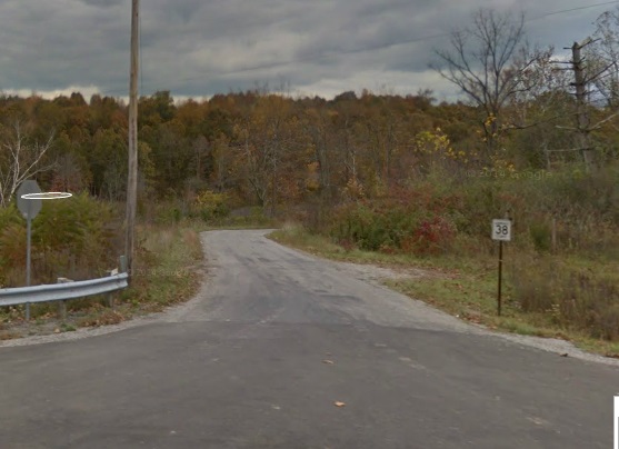
The middle of the night – is this a road? Or someone’s driveway?
As we motored through Athens and into Southern Ohio, we hit a snag. The route called for us to turn off OH-93 in Lawrence County and then go 2 miles east on the ominously sounding “Blackfork-Peniel Road”
That’s an actual Google StreetView picture of the road in question. Looks fine, right? Well, it quickly devolves into a dirt trail through the woods in the middle of the night. It was here that we first coined the term – “Is this a road? Or someone’s driveway?” We probably spent an hour trying to make sure we had crossed the border into Gallia County.
Finishing up
After that fun adventure, the rest of the trip was pretty straightforward. We came in Cincinnati on OH-32, scooted around the northeastern suburbs, up I-71, cut through Xenia and Dayton and then finished our trip in Preble County, coming in at 23 hours, 34 minutes and 34 seconds.
If you’re looking for more information, including in the van trip reports that we phoned in (remember, no smartphones in 2006), you can check the table of contents for the trip out on my old site – everywhatever.com.
I actually submitted this as a record to what was then known as the “Universal Record Database”, now known as recordsetter.com, where it was one of the top 300 records that were included in the RecordSetter.com book of World Records. When the book came out, there was a book tour that came through Cincinnati, and I went on morning TV with Dan and Corey (the co-founders) to talk about my record, and took part in a book signing. So… you know… I’m big time 😉
This site is part of an affiliate sales network and receives compensation for sending traffic to partner sites, such as thepointsguy.com. This may impact how and where links appear on this site. Responses are not provided or commissioned by the bank advertiser. Some or all of the card offers that appear on the website are from advertisers and that compensation may impact on how and where card products appear on the site. Any opinions expressed in this post are my own, and have not been reviewed, approved, or endorsed by my advertising partners and I do not include all card companies, or all available card offers. Terms apply to American Express benefits and offers and other offers and benefits listed on this page. Enrollment may be required for select American Express benefits and offers. Visit americanexpress.com to learn more. Other links on this page may also pay me a commission - as always, thanks for your support if you use them


 Dan Miller travels with his wife and 6 (SIX!) children. He loves to help families travel for free / cheap, especially larger families. If you are looking for help, drop him an email at
I don’t quite understand how you started in Columbus, based on that map. It seems like you’d have to start/finish in Monroe and finish/start in Preble. What am I missing?
You’re right – we did start in Monroe and end in Preble. We stayed the night before in Columbus at a friend’s house, then drove out to Monroe early in the morning the next day and started the clock
Holy crap, it’s been done! I’ve been thinking about doing something like this for some time (my vision would take me through all 88 county seats) but I loved reading that someone else has had a go at it.
With the aide of today’s technology, how much time do you think stands to be shaven off your record if one were to go that route?
I’m not sure that we’d be able to shave that much off the time. I think there is a lot of randomness involved in the trip. We had a lot of things go right, but also lost an hour or so driving around at 3am in the woods trying to find the Gallia County border. I think you’d see a lot of randomness in total times even if you drove this exact same route 100 times. One of the guys that was with me said he thought we would be >24 hours 9 times out of 10. I’m not that pessimistic but it’s certainly possible we’d not have made it.
I would love to do this road trip. Definitely not trying to beat your record. Maybe breaking it down over a couple of days. Would you happen to have an up to date map with directions?
Hi Roz – thanks for reaching out. I don’t have an up-to-date map but if you look at the image you can get a basic idea and then use Google Maps or similar to plan