 Last week, I wrote about how I use the Airline Route Mapper tool to figure out what airlines fly between different cities. Today, I wanted to write about another tool that I’ve used before in trying to plan some of my trips. This one is called Rome2Rio, and it’s useful in figuring out the different transport options when you need to get around a city.
I know that Uber and Lyft are all the rage with most of the travel bloggers, and I know they can definitely be useful, but for me, they are still pretty expensive. I don’t know if most bloggers just have a ton of free rides from referral credits, or if maybe they have different budgets than me, but I literally have never used Uber.
I DID share a Lyft with Shawn from Miles to Memories on our way from the Family Travel for Real Life conference to our hotel (the first hotel I actually gave 5 stars), but again that was a free credit he had. I have 6 kids, so we’d certainly be looking at (at least) 2 Ubers to go anywhere, and even having to pay for 8 bus tickets will still often be cheaper. Generally though, the economics of renting a car are VERY hard to beat for us, though of course, we usually can’t rent just ONE car
(SEE ALSO: Why we’re a 2 (rental) car family)
(SEE ALSO: Using Autoslash to save a ton on your next rental car)
Rome2Rio
Anyways, that is a long-winded way of introducing Rome2Rio, which is kind of like the transit option on Google Maps on steroids. A typical use case for me is getting from the airport to a hotel. Oftentimes, the hotel will have a free airport shuttle, though even that doesn’t always end well
(SEE ALSO: An airport shuttle should not take an hour to show up – Best Western McCarran Inn)
But that’s not always the case. When I had to get to the Hyatt House Charlotte convention center, I had to travel #hobostyle and ended up taking the bus.
On our upcoming trip to Europe, we are flying into Dublin, arriving early in the morning.
(SEE ALSO: How to pick your Aer Lingus seats on an Avios booking)
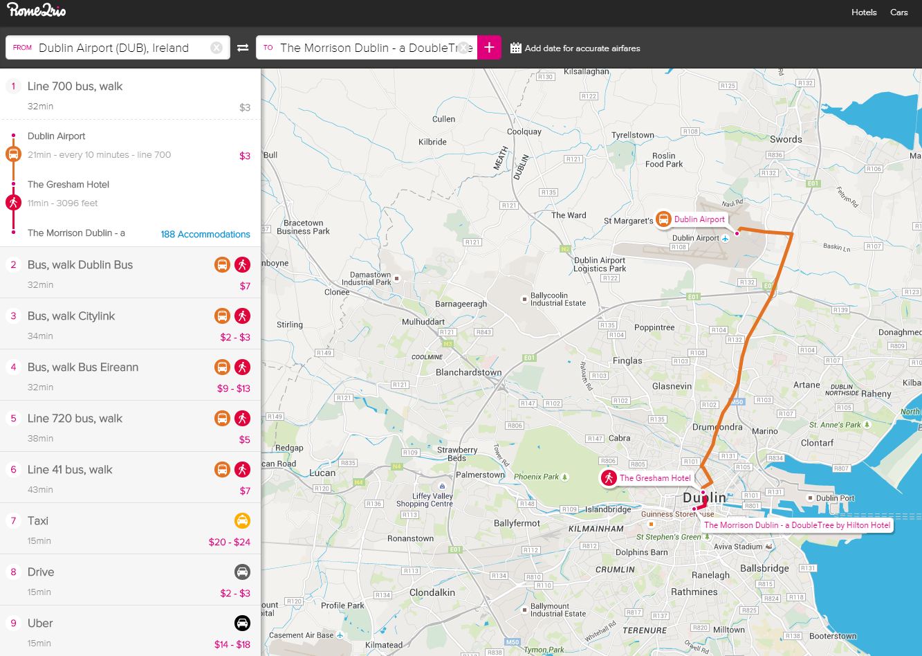
We are looking at staying at the Morrison hotel in downtown Dublin, and there is no airport shuttle. Plugging that info into Rome2Rio, we get
You can see that not only does it give the different options, but it gives their approximate cost, and links for where you can find more information and/or buy tickets (I think buying tickets through the site is how they make money).
It’s nice to be able to compare different options – in this case, it looks like the best option would be the line 700 bus for only $3. There’s also the CityLink bus, but in looking at the timetables, that actually is a commuter bus for other cities and only picks up at Dublin City Centre
Another Rome2Rio example
Continuing on our upcoming European itinerary, we’re going from Dublin to Belfast, before taking a Reward Flight Saver flight from Belfast to London (stopover) and then onwards to Nice, France. This is a flight that used to be free for domestic UK connections (the Belfast-London leg) but due to the recent British Airway devaluation, now is only free if your onward flight is over 2000 miles flown (as opposed to the 649 miles for LHR-NCE)
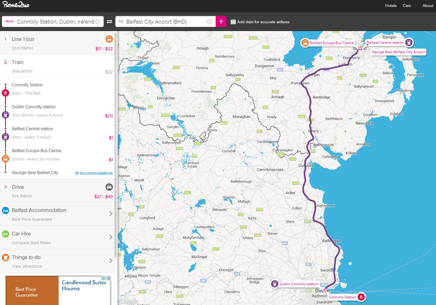
Here’s what Dublin to Belfast looks like in Rome2Rio
So you can see that it gives bus and train examples, along with links to the timetables, so I know that a train leaves Dublin at 7:35 a.m. and 9:35 a.m. I did have a bit of trouble making it recognize the train option – when I put in my hotel’s address, it only gave the bus options. I’m guessing there is a setting somewhere that I’m not aware of.
So far, Rome2Rio has been a great tool in helping to find what kinds of public transportations options there are in unfamiliar cities. Have you ever used it? Share any tips or tricks in the comments!
This site is part of an affiliate sales network and receives compensation for sending traffic to partner sites, such as thepointsguy.com. This may impact how and where links appear on this site. Responses are not provided or commissioned by the bank advertiser. Some or all of the card offers that appear on the website are from advertisers and that compensation may impact on how and where card products appear on the site. Any opinions expressed in this post are my own, and have not been reviewed, approved, or endorsed by my advertising partners and I do not include all card companies, or all available card offers. Terms apply to American Express benefits and offers and other offers and benefits listed on this page. Enrollment may be required for select American Express benefits and offers. Visit americanexpress.com to learn more. Other links on this page may also pay me a commission - as always, thanks for your support if you use them


 Dan Miller travels with his wife and 6 (SIX!) children. He loves to help families travel for free / cheap, especially larger families. If you are looking for help, drop him an email at
Yeah, Rome2Rio is great. My gf and I use it whenever we plan trips. I just found the smartphone app equivalent, called “FetchMyWay” Great great tool!
I’d like to know if anyone’s done a comparison between Google Maps’ transit option and Rome2Rio and/or FetchMyWay to show why one is better than the other. Is the only real difference (the “on steroids” part) the ability to see cost and purchase options?
I have found that Rome2Rio give more options from point A to B. When I have used google maps it might give me 2 bus options but Rome2Rio gives me a whole slew of options, a number of which are far better. From the Airport in Rio de Janerio Google maps has me taking 4 buses to get from the Airport to my Hotel, while Rome2Rio gave me a single bus route that was operated by a For-Profit bus company. It worked out much much better.